Contents
Index
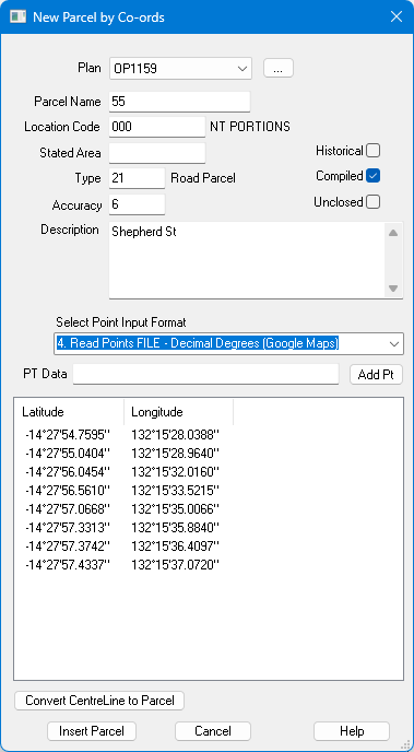
New Parcel by Co-ords
This option can create a 'digitised' parcel by co-ordinates.
The Co-ordinates can be Easting, Northing or Latitude Longitude, including 'Google Maps' co-ordinates.
It can accept co-ordinates one by one or a list of co-ords from a file.
Admin Data
The top half of the dialog allows entry of Parcel admin data.
See Parcel properties for details of these fields
Point Input Format
There are several ways to enter points:
- Paste Latitude, Longitude Decimal Degress (Google Maps)
- Paste Latitude, Longitude DDDMMSS
- Paste Easting, Northing
- Read Points FILE - Decimal Degrees (Google Maps)
- Read Points FILE - DDDMMSS
- Read Points FILE - Easting, Northing
These option provide several methods to enter points into the list on the dialog.
When you have done the centreline or parcel that you want, press 'Insert Parcel'
top convert the points into a parcel in the job.
Insert Parcel
When you have defined the parcel, press this to convert the points into a parcel.
It will convert the Lat,Long values to the current zone and create lines joining the points.
It will compute bearings and distances for the lines.
If the 'Unclosed' box is not ticked it will automatically 'close' the parcel.
Paste Latitude, Longitude Decimal Degress (Google Maps)
This can accept Latitude,Longitude values from Google Maps.
Right click on Google Maps and the top option will be the Lat,Long of click point.
Select the Lat,Long vale and it will be placed in the Clipboard.
Now, Ctrl/V it into the 'PT Data' field, then press 'Add Pt' button.
The point will be inserted into the Latitude, Longitude Points List.
As you enter points, the lines joining the points will be displayed on the main window.
A shortcut is to skip the Ctrl/V step and the 'Add Pt' button will use the clipboard
contents if the 'PT Data' field is empty.
1. Paste Latitude, Longitude DDDMMSS
This can accept Latitude,Longitude values in DDDMMSS format.
You can type them in or paste from another source.
Press 'Add Pt' button to insert the point.
As you enter points, the lines joining the points will be displayed on the main window.
2. Paste Easting, Northing
This can accept Easting, Northing values in the current job zone.
You can type them in or paste from another source.
Press 'Add Pt' button to insert the point, it will be shown in Lat/Long format.
As you enter points, the lines joining the points will be displayed on the main window.
3. Read Points FILE - Decimal Degrees (Google Maps)
This can read a text file of Lat,Long values from a file into the Points List.
The file must have one point per line, Latitude, Longitude (separated by a comma).
The Latitude and Longitude values must be in Decimal Degrees format.
The lines joining the points will be displayed on the main window.
4. Read Points FILE - DDDMMSS
This can read a text file of Lat,Long values from a file into the Points List.
The file must have one point per line, Latitude, Longitude (separated by a comma).
The Latitude and Longitude values must be in DDDMMSS format.
As you enter points, the lines joining the points will be displayed on the main window.
5. Read Points FILE - Easting, Northing
This can read a text file of Easting,Northing (in current zone) values from a file into the Points List.
The file must have one point per line, Easting, Northing (separated by a comma).
As you enter points, the lines joining the points will be displayed on the main window.
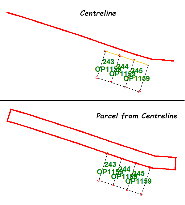
6. Convert Centreline to Parcel
For Road parcels it is much more convenient to enter the road centreline as a series of points.
This option will ask for the road width and will then compute the parallel offset points/lines
to form the road parcel.